The gradient
The gulf-to-range transect
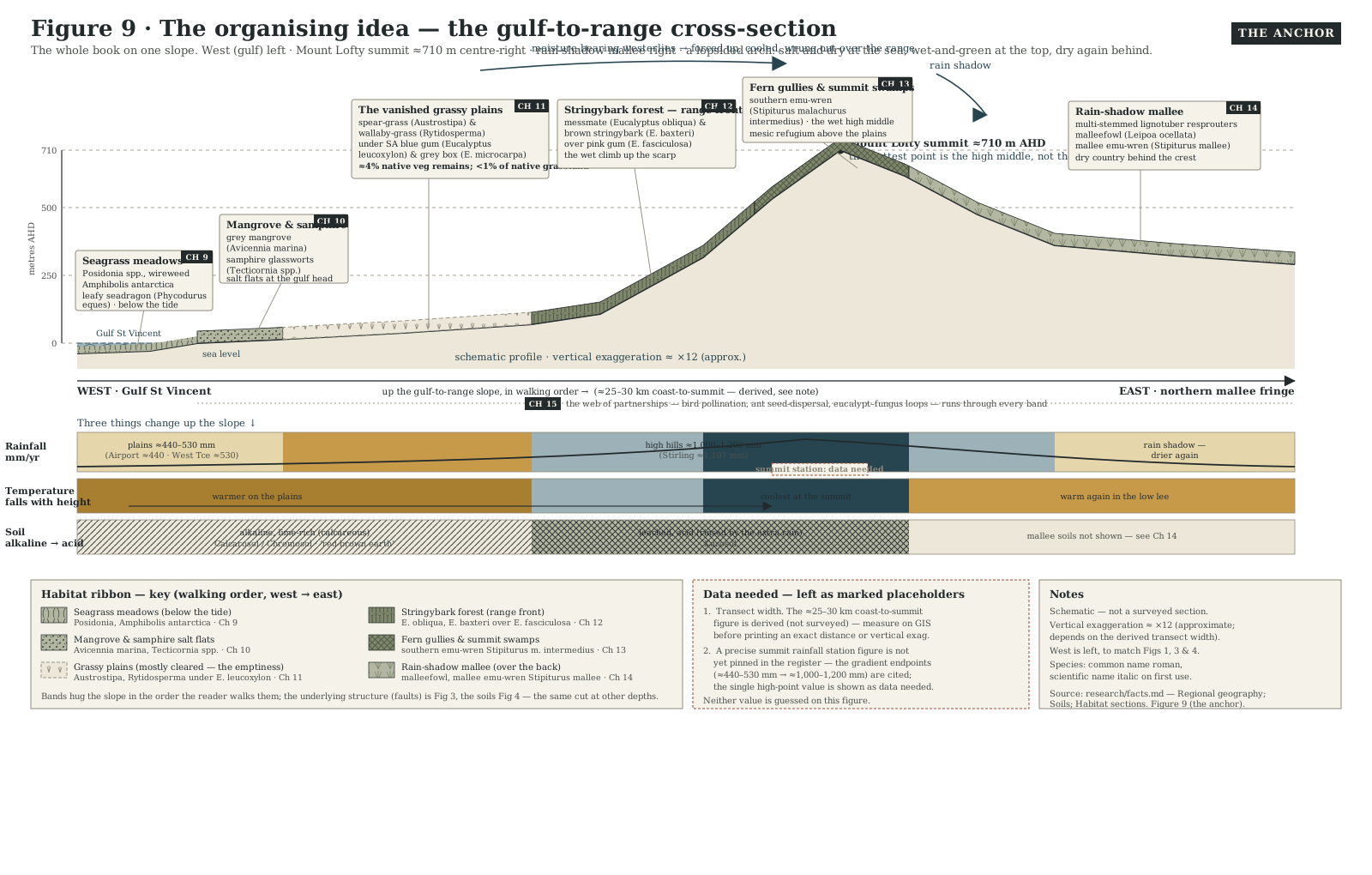
The whole book on one slope — a walkable, driveable cross-section from the floor of Gulf St Vincent to the Mount Lofty summit and down into the rain shadow behind, reading rain, temperature and soil change under your feet as you climb.
- On the gradient
- The entire transect, gulf to summit to rain shadow — every other place, ecosystem and species unit sits somewhere on this one line
- Rock
- A dropped gulf basin, a plain of shed sediment, and a fault-uplifted range block — the whole transect stepping from sea level to over 700 m AHD in some 25–30 km
- Soil
- Alkaline, calcareous plains soils giving way, where the extra rain finally rinses the ground, to leached and acid soils in the wet hills
Locate this place on the map →
What you'll take away
- Walk the whole transect in order — gulf, salt flat, plain, range front, wet gully, summit, rain shadow — and name the community that answers each step.
- Explain the three things that change together as you climb: rainfall rising, temperature falling, and soil turning from alkaline to acid.
- Read the rain shadow as the twist that turns a simple climb into a lopsided arch — the wettest ground is the high middle, not the far end.
Pick any point on the map and you can ask it one question: how far up the slope are you? Everything alive here, from the seagrass on the gulf floor to the mallee behind the last ridge, is arranged along a single short climb — some twenty-five to thirty kilometres from the coast to the top of the Mount Lofty Ranges — and once you see that climb as one thing, the region reads as a sentence, not a scatter of facts.
Start below the waterline. Gulf St Vincent is a sea that runs backwards: instead of freshening as it narrows, it grows saltier toward its head, because evaporation off the shallow northern gulf outpaces the rain and runoff that would otherwise dilute it (de Silva Samarasinghe & Lennon 1987). Step ashore through mangrove and blue-green samphire — the coast’s salt threshold — onto plains that once carried open grassy woodland of spear-grass and wallaby-grass under scattered blue gum and grey box on four or five hundred millimetres of rain a year. Almost none of it is left; barely four per cent of the plains’ native vegetation survives the plough (Kraehenbuehl 1996). Keep climbing and the country changes fast. Force the same sea winds up the range front and they cool and let go of their water, so the high hills catch something like twice the plains’ rain, the air turns cooler and damper, and alkaline plains soil gives way to ground finally rinsed of its lime and salt. Stringybark and messmate crowd the range front, and the wettest folded gullies hide fern, moss, and a thread-tailed scrap of a bird, the southern emu-wren, needing cover this dense and this wet just to exist.
Here is the twist that turns a climb into an arch. The ranges do not merely catch the rain; they steal it, so air spent on the summit forest arrives over the crest already wrung dry, and the country just behind is thrown back into a different, inland dry: the rain shadow. Tall wet forest thins within a few kilometres into mallee — low, multi-stemmed eucalypts resprouting from a woody underground swelling after fire, over spinifex or saltbush, on perhaps a third of the summit’s rain (Foulkes & Gillen 2000). None of this stepped terrain is an accident of erosion; the transect has been built, and is still being built, by faults shoving the ranges skyward faster than their summits wear down (Quigley et al. 2010).
That is the gradient, walked once: salt, plain, range front, summit, dry again over the back — one climb, four kinds of country, and every other unit in this guide is a closer look at one step of it.
Sources for this guide · 5
Every claim here is traceable. Each citation links to its entry in the bibliography.
- Gill, A.M., McKenna, D.J. & Wouters, M.A. (2014). Landscape fire, biodiversity decline and a rapidly changing milieu: a microcosm of global issues in an Australian biodiversity hotspot. Land 3(3): 1091–1136. DOI: 10.3390/land3031091. https://www.mdpi.com/2073-445X/3/3/1091 — The coast-to-hills rainfall gradient and the Mount Lofty Ranges as a national biodiversity hotspot.
- Quigley, M.C., Clark, D. & Sandiford, M. (2010). Tectonic geomorphology of Australia. Geological Society, London, Special Publications 346:243–265. https://doi.org/10.1144/SP346.13 — Fault-driven uplift stepping the land from gulf floor to summit over the last few million years.
- de Silva Samarasinghe, J.R. & Lennon, G.W. (1987). Hypersalinity, flushing and transient salt-wedges in a tidal gulf — an inverse estuary. Estuarine, Coastal and Shelf Science 24(4): 483–498. https://www.sciencedirect.com/science/article/abs/pii/0272771487901296 — Gulf St Vincent's inverse-estuary salinity gradient, the transect's saltwater starting point.
- Kraehenbuehl, D.N. (1996). Pre-European Vegetation of Adelaide: A Survey from the Gawler River to Hallett Cove. Adelaide: Nature Conservation Society of South Australia (317 pp.). https://catalogue.nla.gov.au/catalog/1474359 — The grassy woodland the Adelaide Plains carried before clearance, and how little of it remains.
- Armstrong, D.M., Croft, S.J. & Foulkes, J.N. (2003). A Biological Survey of the Southern Mount Lofty Ranges, South Australia, 2000–2001. Department for Environment and Heritage, South Australia. https://data.environment.sa.gov.au/Content/Publications/Southern-Mount-Lofty-Ranges-BioSurvey.pdf — The mallee vegetation and fauna surveyed behind the ranges, in the rain shadow at the transect's dry end.
Concepts this teaches — follow a thread
The gradient (reading ecology as a climb)The Mediterranean bargain (two seasons, not four)The mesic refugium (a wet island in a dry land)The rain shadow (the dry side of the hills)
Part of these pathways
The gradient (for students)The whole gradient — gulf to summit
Test yourself →
You're driving inland, having just crested the wettest, ferniest gully high in the Mount Lofty summit forest. Within only a few kilometres on the inland side of the crest, the tall wet forest is gone: low, multi-stemmed eucalypts resprout from a woody underground swelling over spinifex and saltbush, and the air feels suddenly hot and dry although you're barely off the summit. Which step of the gulf-to-range transect are you now reading?
Cues: Just crested the wettest, fern-and-moss gully near the summit · Within a few kilometres downhill, the tall wet forest is simply gone · Low, multi-stemmed eucalypts resprouting from a woody rootstock, over spinifex and saltbush · Air turns suddenly hot and dry, despite being barely off the summit
This is the transect's twist: the ranges don't just catch the rain, they steal it, so air spilling over the crest arrives already wrung dry and the country just behind is thrown into a different, inland dry. Tall wet summit forest can thin within a few kilometres into mallee — low, multi-stemmed eucalypts resprouting from a lignotuber over spinifex or saltbush — on perhaps a third of the summit's rainfall (Foulkes & Gillen 2000). The other three options are each an earlier, wetter or saltier step of the same climb, not this one.