An ecosystem
The vanished grassy plains
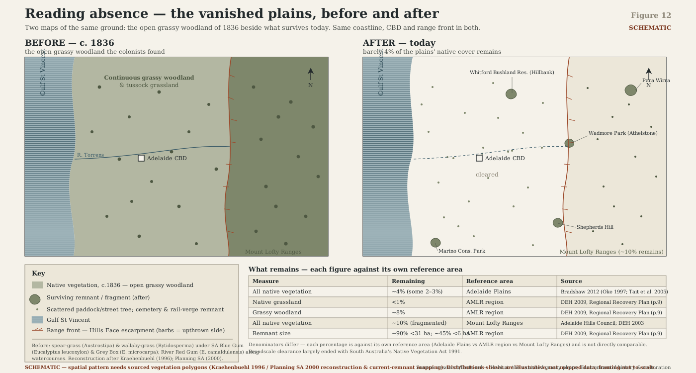
The open blue-gum-and-grey-box grassy woodland the colonists found across the Adelaide Plains is almost entirely gone — learn to read the lone paddock tree, the fenced verge and the roadside grass strip as the last four per cent.
- On the gradient
- The plains proper — the flat, once grassy-wooded step of the gulf-to-range gradient, and its most cleared
- Rock
- Quaternary alluvial and aeolian sediment over the St Vincent Basin — the flat coastal-plain apron between the gulf and the range front
- Soil
- Red-brown earths — duplex, texture-contrast soils, a pale sandy topsoil over a dense, sodic clay subsoil
Locate this place on the map →
What you'll take away
- Identify open grassy woodland — scattered SA blue gum and grey box over a continuous floor of spear-grass and wallaby-grass — as the Adelaide Plains' original vegetation, not incidental paddock scenery.
- Explain why the richest, flattest, easiest ground was cleared first and almost completely, and connect that to the ~4% of native vegetation now surviving on the plains.
- Read three concrete clues to the vanished woodland — the lone open-grown paddock gum, the fenced cemetery or rail verge, the roadside grass strip — as detective evidence, not sentimental scenery.
- Keep the plains' ~4%-of-all-vegetation figure distinct from the region's <1%-of-grassland figure, so the two are never quoted as if they were the same number.
Stand anywhere on the built-up apron that runs between the hills and the gulf — a supermarket car park, a suburban oval, a six-lane arterial road — and try to picture what stood there before 1836. You will fail, and that failure is the whole point of this entry: no ground in the Adelaide story has been so thoroughly rewritten.
What the first colonists found, stepping off their ships, was neither forest nor bare grassland but something lovelier than either: open grassy woodland. Scattered stands of South Australian blue gum and grey box, with river red gums tracing the creek lines, rose out of a continuous tussock floor of spear-grass and wallaby-grass, spaced widely enough that the whole plain read as parkland rather than bush (Planning SA 2000). One colonial official, walking the future city site in December 1836, described grass “three or four feet high” over a tract “of the most luxuriant description” — which sounds like flattery until you remember it explains, better than any later argument could, why the settlers took the ground so fast and so completely. It looked ready-made.
That was its undoing. Flat, fertile, easy to plough and close to the water and the port, the plains were the richest country in the whole gulf-to-range transect. Rich, easy country is always cleared first, and cleared hardest. There was no single catastrophe, no fire or flood to mark it; just two centuries of fence, furrow and subdivision, working steadily at a landscape that put up no resistance. The tally now stands at something like four per cent of the plains’ original native vegetation surviving at all (Bradshaw 2012), and the tussock grassland that once carpeted the ground under those scattered trees is rarer again — scarce enough that conservationists today still name it among the region’s most endangered plant communities (Green Adelaide 2025). That we can even describe the lost woodland with any confidence is mostly the work of one patient man. Darrell Kraehenbuehl spent decades reading colonial surveyors’ field notebooks and tracking down the handful of surviving scraps, and in 1996 rebuilt, paddock by paddock, a landscape almost nobody alive had ever walked through (Kraehenbuehl 1996).
None of which means the plains have nothing left to read. That huge, low-branched gum standing alone in a stock paddock or a school oval is not a garden escapee; grown wide and open like that, it is very likely a genuine survivor of the vanished woodland, spared because it was too big, or too useful for shade, to bother felling. That unfamiliar, wispy grass fringing an old railway cutting or fenced inside a country cemetery may be the plains’ true original ground layer, saved by nothing grander than an accident of fencing that kept the plough and the stock out. Read it properly, and a paddock stops being scenery and becomes a crime scene with the evidence still standing.
Go deeper — the mechanism & the evidence
Three separate communities carry this loss onto the nation's threatened-ecosystem list, and each runs its own arithmetic, which is worth holding apart rather than averaging into one tidy number. The Iron-grass Natural Temperate Grassland — once perhaps three-quarters of a million hectares or more along the ranges' eastern edge — has lost upward of ninety-five per cent of its extent and is listed Critically Endangered; only a few thousand hectares still meet the listing's own condition standard, and well under a thousand sit in formal reserve (DEWHA 2007). The Peppermint Box Grassy Woodland, once around nine hundred thousand hectares, is down to a low single-digit percentage of that and is Critically Endangered too (DEWHA 2007). Neither figure is the plains' own four per cent of all vegetation (Bradshaw 2012) — they are narrower communities measured against their own pre-1836 baselines, and conflating the numbers is the easiest way to misquote this ground. What all three share is the slower, second insult: fragmentation. A remnant too small and too isolated keeps losing species for decades after the last clearing, a debt still being paid out in patches across the region (Szabo 2011) — which is exactly why conservationists can still, in 2025, call native grassland one of Adelaide's most endangered plant communities, close to two centuries after the plough first arrived (Green Adelaide 2025).
Sources for this guide · 6
Every claim here is traceable. Each citation links to its entry in the bibliography.
- Kraehenbuehl, D.N. (1996). Pre-European Vegetation of Adelaide: A Survey from the Gawler River to Hallett Cove. Adelaide: Nature Conservation Society of South Australia (317 pp.). https://catalogue.nla.gov.au/catalog/1474359 — The decades-long reconstruction of the Adelaide Plains' pre-1836 grassy woodland, built from colonial surveyors' field notes and surviving remnant scraps.
- Bradshaw, C.J.A. (2012). Little left to lose: deforestation and forest degradation in Australia since European colonization. Journal of Plant Ecology 5(1): 109–120. DOI: 10.1093/jpe/rtr038. https://doi.org/10.1093/jpe/rtr038 — The ~4% figure for native vegetation remaining on the Adelaide Plains.
- Planning SA / Department for Environment and Heritage (2000). Forests and Woodlands of the Adelaide Plains in 1836: A Native Vegetation Planting Guide (map published Sept 1997, revised May 2000; based on D.N. Kraehenbuehl). https://data.environment.sa.gov.au/Content/Publications/Forests_Woodlands_Ad_Plains_1836.pdf — The 1836 vegetation planting guide — dominant species (SA blue gum, grey box, river red gum) and open woodland structure of the pre-settlement plains.
- Green Adelaide (2025). What you need to know about one of Adelaide's most endangered plant communities [native grasslands]. https://www.greenadelaide.sa.gov.au/news/2025-native-grasslands-adelaide — Native grassland's current standing as one of Adelaide's most endangered plant communities.
- Department of Sustainability, Environment, Water, Population and Communities / DEWHA (2007, 2012). Peppermint Box (Eucalyptus odorata) Grassy Woodland of South Australia — EPBC Act listing (Critically Endangered, 2007) and National Recovery Plan (2012). https://www.dcceew.gov.au/environment/epbc/publications/peppermint-box-eucalyptus-odorata-grassy-woodland-south-australia-and-iron-grass-natural ; https://www.agriculture.gov.au/sites/default/files/documents/peppermint-box-grassy-woodland.pdf — EPBC listing of the Iron-grass Natural Temperate Grassland and Peppermint Box Grassy Woodland as Critically Endangered, with their own loss percentages.
- Szabo, J.K., Baxter, P.W.J., Vesk, P.A. & Possingham, H.P. (2011). Paying the extinction debt: woodland birds in the Mount Lofty Ranges, South Australia. Emu — Austral Ornithology 111(1): 59–70. DOI: 10.1071/MU09114. https://www.publish.csiro.au/mu/mu09114 — Fragmentation and extinction-debt dynamics in small, isolated remnants of the region's cleared woodland.
Concepts this teaches — follow a thread
Clearance and fragmentation (the great clearing)The shifting baselineRed-brown earths — the plains' difficult soils
More guides like this
Stringybark countryThe fern gulliesThe Fleurieu peat swampsThe rain-shadow malleeThe seagrass meadows
Part of these pathways
Test yourself →
You're crossing the flat Adelaide Plains between the gulf and the range front. In a stock paddock stands one huge, wide-crowned gum, branching low and open, with nothing else like it for a kilometre around. Along an old fenced rail cutting nearby grows a strip of unfamiliar, wispy grass that isn't in any of the surrounding paddocks. What are you reading here?
Cues: One huge, wide-crowned, low-branched gum standing alone in an otherwise open paddock · No other trees of its kind anywhere nearby — it doesn't belong to a planted row or windbreak · A strip of unfamiliar, wispy grass confined to a fenced rail cutting or verge · That grass is absent from the ploughed or grazed paddocks right beside it · Flat, cleared plain between the gulf and the ranges, on deep red-brown clay soil
The Adelaide Plains once carried open woodland of scattered SA blue gum and grey box over a continuous tussock floor of spear-grass and wallaby-grass, but flat, fertile, easy-to-plough ground was cleared first and hardest, leaving only about four per cent of the plains' original native vegetation standing today (Bradshaw 2012). A single open-grown gum too big or useful to bother felling, and a grass strip saved only by a fence line, are exactly the kind of physical evidence that reconstructions of the lost woodland were built from (Kraehenbuehl 1996).