A force
Deep time in the rock
Eight hundred million years compressed into one blue wall behind the city — a stalled rift, two ice ages that iced the whole planet, the first known animals, and a young fault system still lifting the land under your feet.
- On the gradient
- The ground beneath and behind the whole transect — the dropped gulf basin and the risen ranges block are both this rift's doing
- Rock
- Adelaide Rift Complex sediment, folded by the Delamerian Orogeny and reactivated by young range-front faulting
- Soil
- Not the point here — the rock itself, and the faults still moving beneath it, are the story
Locate this place on the map →
What you'll take away
- Read the Mount Lofty Ranges as a rift basin's fill, mountain-built twice — once by the Delamerian Orogeny around 514 million years ago, worn to its roots, then revived by young faulting in just the last few million years.
- Place the Sturtian and Marinoan 'Snowball Earth' glaciations and the Ediacaran fossil dawn in their correct order within that stalled rift's long fill, without conflating the two ice ages or misdating the fossils.
- Explain why the ranges are still rising today — old rift faults reactivated by continental-scale compression — and connect that ongoing lift to Adelaide's exposure to earthquakes.
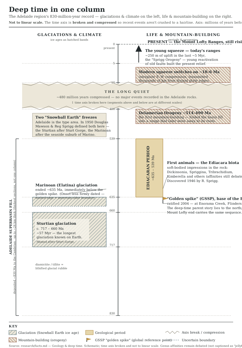
Every so often a landscape hands you an origin story you can put your hand on, and the blue wall of hills behind Adelaide is one of the biggest going. Around 830 million years ago, the continent that would one day carry this city on its skin began to pull itself apart along a line roughly where the ranges now stand — a rift, the geologist’s word for a break that stalled before it could finish the job and open an ocean. For the better part of three hundred million years the abandoned trough did what troughs do: it filled, river mud and shallow-sea sand and, for one long stretch, ground-up glacial rubble piling up layer on layer until in its thickest sections the pile reached something like twenty-four kilometres (Preiss 2000).
Read that pile in order and you meet two of the strangest chapters the planet has on offer. First came the Sturtian glaciation, a freeze that by the best current dating ran for something like fifty-seven million years and may have iced the globe from pole to pole — Snowball Earth, as it is now called, only half-jokingly — its very end pinned by a volcanic ash bed to 663.03 million years ago, almost to the day (Cox et al. 2018). A second, shorter freeze, the Marinoan, followed and closed around 635 million years ago, and lying directly on its retreating ice-rubble is the first rock of a whole new era: the Ediacaran, named for fossils found a few hundred kilometres north in this same rift system, the earliest large, complicated animal life anyone has yet found on the planet (Knoll et al. 2006).
Around 514 million years ago the whole accumulated stack — ice-age rubble, sea mud and all — was crushed and folded skyward by a continental collision, the Delamerian Orogeny, into a mountain range (Foden et al. 2006). That range then wore back down, in places nearly to a plain, over hundreds of millions of quiet years.
The hills you see today, then, are a second, much younger act, not that first range — the same old rift-bounding faults waking up again in just the last several million years, shoving old basement rock up and over the young plains at something like fifty metres every million years (Sandiford 2003). That is slow by any human clock, and entirely real: more known active faults run within reach of Adelaide’s suburbs than of any other Australian capital, and the range in the rear-view mirror is not scenery. It is a machine, still mid-stroke — the stage this rift built, and the faults keep lifting.
Go deeper — the mechanism & the evidence
The rift's full name is a small genealogy in itself: once the "Adelaide Geosyncline," now formally the Adelaide Rift Complex, sitting within the wider Adelaide Superbasin, a Neoproterozoic-to-Cambrian succession whose cumulative fill runs to something like 24 km in its thickest sections (Preiss 2000). Onto that fill fell the two Snowball Earth freezes in turn. The Sturtian's end is dated by U–Pb zircon in a Wilyerpa Formation tuff to 663.03 ± 0.11 Ma (Cox et al. 2018); the Marinoan's end is marked stratigraphically rather than radiometrically — the exact bedding plane where its glacial diamictite gives way to the Nuccaleena cap carbonate is the ratified base of the Ediacaran Period, its global reference point fixed at Enorama Creek in the Flinders Ranges when the period was formally declared in 2004 (Knoll et al. 2006). The Delamerian Orogeny folded that whole pile into a mountain range over roughly twenty million years, its main phase running from about 514 million years ago (Foden et al. 2006). The modern uplift is a separate, much younger reactivation of the same old faults, driven by an intraplate compressional stress field that only switched on in the last ten to six million years — and still measurable today in something like 250 metres of range-front uplift over the last five million years (Sandiford 2003).
Sources for this guide · 5
Every claim here is traceable. Each citation links to its entry in the bibliography.
- Preiss, W.V. (2000). The Adelaide Geosyncline of South Australia and its significance in Neoproterozoic continental reconstruction. Precambrian Research 100(1–3): 21–63. https://www.sciencedirect.com/science/article/abs/pii/S0301926899000686 — The Adelaide Rift Complex/Geosyncline — the stalled rift and its basin fill.
- Foden, J., Elburg, M.A., Dougherty-Page, J. & Burtt, A. (2006). The timing and duration of the Delamerian Orogeny: correlation with the Ross Orogen and implications for Gondwana assembly. The Journal of Geology 114(2): 189–210. https://www.journals.uchicago.edu/doi/abs/10.1086/499570 — Timing of the Delamerian Orogeny that first folded the rift fill into a mountain range.
- Cox, G.M. et al. (2018). U–Pb (CA-ID-TIMS) zircon age of 663.03 ± 0.11 Ma for a tuff in the Wilyerpa Formation, Adelaide Superbasin (cited via Lloyd et al. 2023; original details to confirm from that paper). https://www.cambridge.org/core/journals/geological-magazine/article/geochronology-and-formal-stratigraphy-of-the-sturtian-glaciation-in-the-adelaide-superbasin/1D635EDFDB155C19FF8481D178F86AC7 — U–Pb dating pinning the end of the Sturtian glaciation recorded in the rift fill.
- Knoll, A.H., Walter, M.R., Narbonne, G.M. & Christie-Blick, N. (2006). The Ediacaran Period: a new addition to the geologic time scale. Lethaia 39(1): 13–30. DOI: 10.1080/00241160500409223. https://onlinelibrary.wiley.com/doi/10.1080/00241160500409223 — The Ediacaran ratified as a new geological period, its GSSP fixed nearby in the Flinders Ranges.
- Sandiford, M. (2003). Neotectonics of southeastern Australia: linking the Quaternary faulting record with seismicity and in situ stress. Geological Society of Australia Special Publication 22:107–119. — Uplift rates showing the ranges' young, ongoing reactivation along the old rift faults.
Concepts this teaches — follow a thread
The Adelaide RiftThe Ediacaran dawnSnowball Earth (the Sturtian & Marinoan glaciations)A continent that still moves
More guides like this
Part of these pathways
Test yourself →
The Mount Lofty Ranges you see behind Adelaide today were built twice. What produced the second, more recent uplift — the one still measurable today?
The range's first mountain-building was the Delamerian Orogeny around 514 million years ago, which then wore back down almost to a plain over hundreds of millions of years (Foden et al. 2006). The hills standing today are a separate, much younger act: the same old rift-bounding faults waking up again under a continental-scale compressional stress field, lifting the range front at something like 250 metres over the last five million years (Sandiford 2003). Mistaking the second uplift for a continuation of the first collapses two very different events, hundreds of millions of years apart, into one.