A place
Hallett Cove — the glacial pavement
A coastal reserve where a bare rock floor, grooved and polished by an ice sheet, sits directly on the tilted, half-billion-year-old wreckage of the rift basin that built the ranges — two ice ages and a lost mountain range in one clifftop walk.
- On the gradient
- The sea's edge of the range-front story — where the ancient rift floor and the still-rising coast meet Gulf St Vincent
- Rock
- Ice-scoured Permian pavement and erratics unconformably overlying tilted, folded Adelaide Rift Complex sediment
- Soil
- Thin, skeletal coastal soil over bare exposed bedrock — here the rock itself is the story, not what grows on it
Locate this place on the map →
What you'll take away
- Read the pavement's grooves, polish and stranded boulders as the signature of a moving ice sheet dragging rock across rock, not the work of the sea or a quarry.
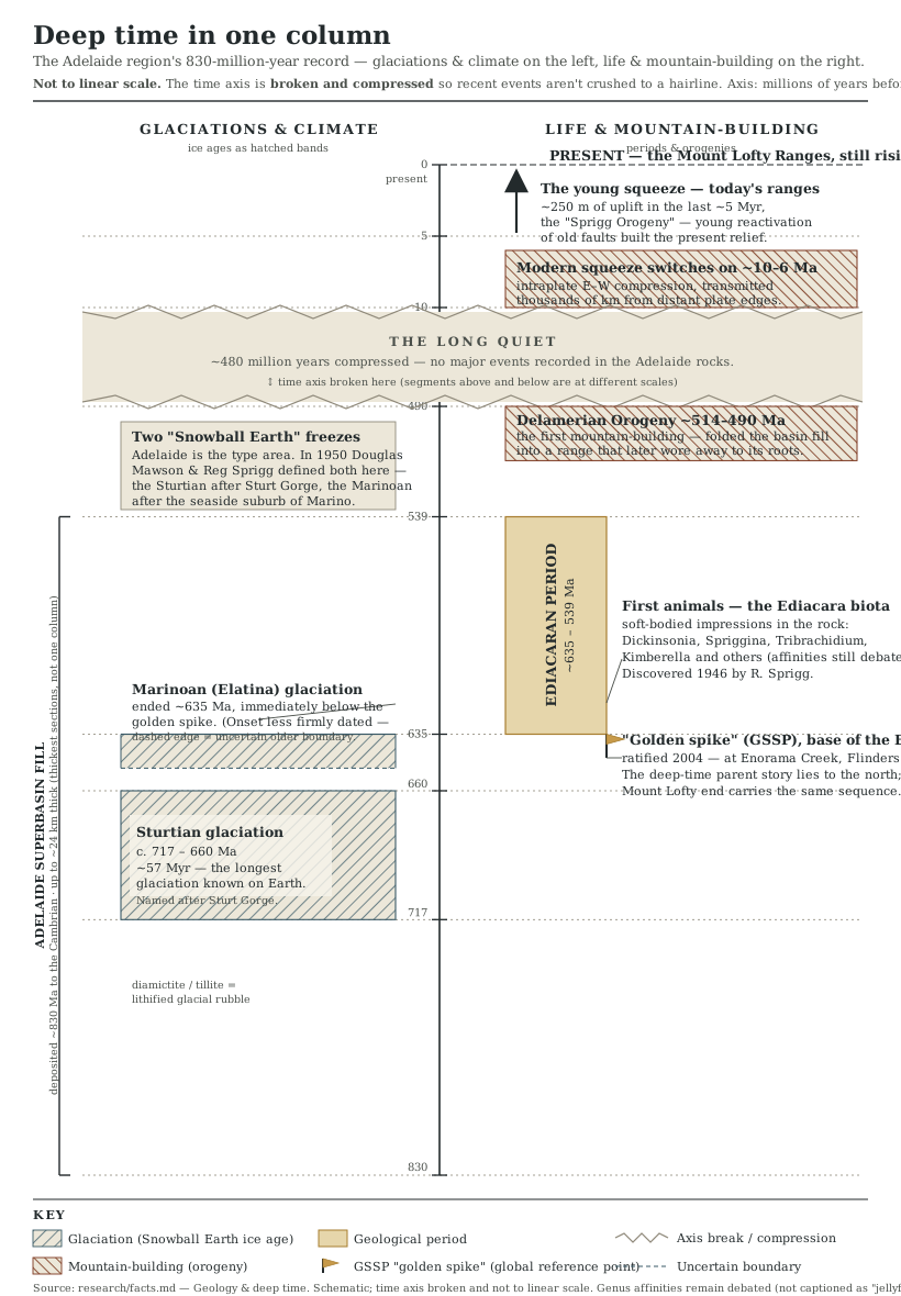
- Explain why the rock beneath the ice-scour stands on end rather than lying flat — link it to the Adelaide Rift Complex's sediment pile and the Delamerian Orogeny that first folded it into a mountain range.
- Distinguish this pavement's ice age from the much older Sturtian and Marinoan 'Snowball Earth' glaciations named a few kilometres up this same coast, so the two are never conflated.
- Connect the cove to the region's ongoing uplift — the same slow rise that lifts the Mount Lofty Ranges is what has carried this ancient, buried sequence back up into the light at the coast.
Most coves give you a beach. Hallett Cove gives you a floor plan of deep time, laid out flat enough to walk on.
Underfoot is a pavement of bare rock, grooved and polished in long parallel scratches, with the odd out-of-place boulder — an “erratic” — sitting stranded on top of it like a delivery nobody collected. That is not weather or wave-work; it is the unmistakable signature of an ice sheet dragging rock and grit across rock, the same handwriting you would read on a scoured surface in Antarctica today, left here as the ice advanced, dropped its cargo and melted away (Bourman et al. 2016).
What makes the cove more than a curiosity is what that ice ground its grooves across. The rock beneath the pavement is not lying flat, the way sediment settles. It stands tilted, sometimes almost on end — the folded, upended remains of the same vast rift-basin fill that piled up, kilometre on kilometre, in the Adelaide Rift Complex, then was crushed and shoved into a genuine mountain range by the Delamerian Orogeny some 514 million years ago (Preiss 2000; Foden et al. 2006). That range wore itself away long before this ice ever arrived, leaving a worn, tilted stump of sea-floor sediment for a much younger glacier to scrape flat. Two entirely different chapters of the planet’s history, one lying directly across the other, in a cove you can cross in a few minutes.
The coast just north of here lends its name to a much older, far stranger freeze, and the two are easy to confuse. Marino, the next beach up, gave its name to the Marinoan glaciation, one of the two “Snowball Earth” ice ages Douglas Mawson and Reg Sprigg identified and named from this same stretch of country in 1950, episodes hundreds of millions of years older than the ice that scoured this pavement (Mawson & Sprigg 1950). Hallett Cove’s ice came later, ground across rock that was already ancient when it arrived, and left before the ranges behind the city had even begun their ongoing rise — the same slow uplift that has since carried this whole buried, folded, ice-worn sequence back up to where the tide can wash across it. Stand on the pavement and you are on at least three ages of the country’s history at once, still legible, still exposed, entirely by accident of the coast wearing back to meet it.
Sources for this guide · 4
Every claim here is traceable. Each citation links to its entry in the bibliography.
- Bourman, R.P., Murray-Wallace, C.V. & Harvey, N. (2016). Coastal Landscapes of South Australia. Adelaide: University of Adelaide Press. ISBN 978-1-925261-21-9. https://www.adelaide.edu.au/press/titles/coast-sa — Hallett Cove's ice-scoured pavement and erratics within the broader coastal-landscape record of South Australia.
- Preiss, W.V. (2000). The Adelaide Geosyncline of South Australia and its significance in Neoproterozoic continental reconstruction. Precambrian Research 100(1–3): 21–63. https://www.sciencedirect.com/science/article/abs/pii/S0301926899000686 — The Adelaide Rift Complex — the tilted, folded rift-basin sediment the pavement sits on.
- Foden, J., Elburg, M.A., Dougherty-Page, J. & Burtt, A. (2006). The timing and duration of the Delamerian Orogeny: correlation with the Ross Orogen and implications for Gondwana assembly. The Journal of Geology 114(2): 189–210. https://www.journals.uchicago.edu/doi/abs/10.1086/499570 — The Delamerian Orogeny that first folded this rift-basin pile into a mountain range.
- Mawson, D. & Sprigg, R.C. (1950). Subdivision of the Adelaide System. Transactions of the Royal Society of South Australia 73 (definitional 'Sturtian'/'Marinoan' — verify pagination). — Naming of the much older Sturtian and Marinoan glaciations at Sturt Gorge and neighbouring Marino, for contrast with this younger ice.
Concepts this teaches — follow a thread
The Adelaide RiftSnowball Earth (the Sturtian & Marinoan glaciations)A continent that still moves
More guides like this
Barker InletCleland — the range frontKarrawirra Pari — the TorrensMorialta — a hills gorgeMount Lofty summitNgarkat — the great mallee reserve
Part of these pathways
Test yourself →
You are walking across a bare, gently sloping rock floor at the coast. The surface is smoothed and polished, scored with long parallel scratches all running the same way, and here and there an out-of-place boulder of different rock sits stranded on top, as if dropped from nowhere. Where the floor's edge is cut away, the rock beneath is not flat-lying — it stands tilted, almost on end. What are you standing on?
Cues: A bare rock pavement, smoothed and polished, not sand or soil · Long parallel scratches and grooves all running one direction · An isolated 'erratic' boulder of foreign rock stranded on the surface · The rock beneath the polished floor stands tilted, almost on end, rather than lying flat
The polish, parallel scratches and stranded erratic are the signature of a moving ice sheet, not surf or machinery — surf rounds and sorts, it does not leave one-directional scratches, and a quarry floor would not carry a foreign boulder (Bourman et al. 2016). The tilted rock the ice ground across is the older tell: it is the folded, upended Adelaide Rift Complex, crushed into a mountain range by the Delamerian Orogeny long before this ice ever arrived. This pavement's ice is younger still than the Sturtian and Marinoan 'Snowball Earth' glaciations named a few kilometres up the coast at Marino — a different, far older freeze entirely, so the two must not be conflated (Mawson & Sprigg 1950).