A place
Mount Lofty summit
A railed lookout a little over 710 m above the plains where, on a clear day, the whole gulf-to-range argument of the book lies open in front of you at once.
- On the gradient
- The high middle of the transect — where the climb from the gulf peaks before tipping back down into the rain-shadow mallee
- Rock
- Fault-uplifted crest of the southern Mount Lofty Ranges, above the down-dropped St Vincent Basin
- Soil
- Leached, acid forest soils on ancient, deeply weathered bedrock
Locate this place on the map →
What you'll take away
- Read the view from the summit as a cross-section, not scenery — naming, in order, the gulf, the plains, the range front and the summit forest laid out below.
- Explain why the summit is the wettest point on the whole transect, and why the country immediately behind it is drier again — the rain-shadow twist that turns a simple climb into a lopsided arch.
- Connect the summit's height and position to the rift-and-fault geology of Part 1, and its cool, wet forest to the mesic refuge it shelters.
Go up to the railed platform on top of Mount Lofty, a little over seven hundred metres above the sea and some fifteen kilometres east of the city, and you are not so much admiring a view as reading a diagram.
Most of the roughly 350,000 people a year who make the climb come for the skyline — the grey-green quilt of the suburbs running out to the bright thread of Gulf St Vincent, with Yorke Peninsula and, if the day is generous, Kangaroo Island lying low on the horizon beyond.
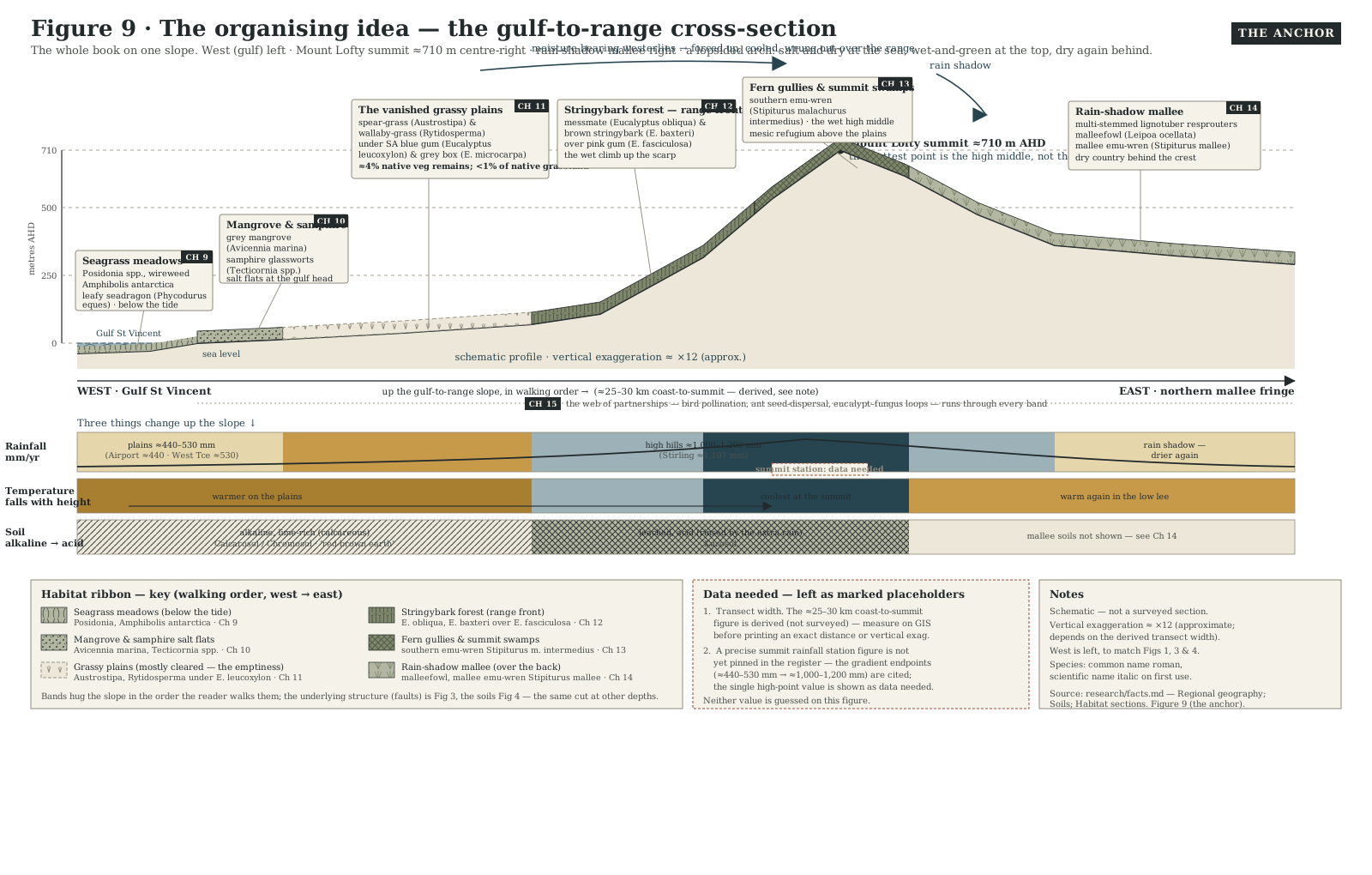
Look at it as a naturalist instead and the same view turns into a cross-section, the whole gulf-to-range transect laid out below you at a glance: salt water, plain, range front, summit forest, all stacked in the order they occur on the ground.
It helps that Mount Lofty has been a reference point for exactly this reading since the country was first charted from outside.
Matthew Flinders picked out the summit from the deck of the Investigator in 1802, fixing it as the landmark peak of “the ridge of mountains” running north behind the gulf, and the name has anchored the map ever since (Flinders 1814).
It is, despite its name, a modest peak — the high point of only the southern Mount Lofty Ranges, not the whole chain, an honour that belongs to Mount Bryan, well to the north and considerably taller.
What earns Mount Lofty the climb is its position, not its height: a single platform from which almost the entire argument of this book can be taken in at once.
Everything below has arranged itself according to one changing ration of rain.
The dry plains at the mountain’s foot make do with a few hundred millimetres a year; force the same sea winds up the range front and they cool, wring themselves out, and hand the high ranges something like twice that total, one of the widest rainfall swings you can drive across in twenty minutes anywhere in the country (Gill 2014).
That is also why the forest around the lookout — stringybark and messmate, with tree ferns crowding the damp gullies below — counts among the plants and birds of one of Australia’s fifteen national biodiversity hotspots: a cool, wet island held up against a drying continent by nothing more than altitude (Gill 2014).
There is a twist worth carrying back down the hill.
The ranges do not just catch the rain, they steal it, so the country over the crest, in the immediate lee of this summit, is thrown into a rain shadow and tips straight back down into mallee — meaning the wettest ground on the whole transect is this high middle, not the far end of it, and the gradient is less a ramp than a lopsided arch.
None of it would exist to be read at all without the slow violence underneath it: this block of ranges has been shoved up along active faults for millions of years, rising faster than even the toughest summit rock can be worn back down, which is the patient, ongoing reason there is a mountain here to climb in the first place (Quigley 2010).
Sources for this guide · 3
Every claim here is traceable. Each citation links to its entry in the bibliography.
- Flinders, M. (1814). A Voyage to Terra Australis, Vol. I. G. & W. Nicol, London. (chapter epigraphs: Chs 3, 4, 7, 8) — Matthew Flinders' 1802 sighting and naming of the summit landmark from the deck of the Investigator.
- Gill, A.M., McKenna, D.J. & Wouters, M.A. (2014). Landscape fire, biodiversity decline and a rapidly changing milieu: a microcosm of global issues in an Australian biodiversity hotspot. Land 3(3): 1091–1136. DOI: 10.3390/land3031091. https://www.mdpi.com/2073-445X/3/3/1091 — Coast-to-hills rainfall gradient (plains vs ranges spine) and the Mount Lofty Ranges as a national biodiversity hotspot.
- Quigley, M.C., Clark, D. & Sandiford, M. (2010). Tectonic geomorphology of Australia. Geological Society, London, Special Publications 346:243–265. https://doi.org/10.1144/SP346.13 — Fault-driven uplift of the range block against slow summit erosion — why the ranges still stand this high.
Concepts this teaches — follow a thread
The gradient (reading ecology as a climb)The rain shadow (the dry side of the hills)The mesic refugium (a wet island in a dry land)
More guides like this
Barker InletCleland — the range frontHallett Cove — the glacial pavementKarrawirra Pari — the TorrensMorialta — a hills gorgeNgarkat — the great mallee reserve
Part of these pathways
Test yourself →
You're standing at the railed lookout on top of Mount Lofty on a clear day. Facing west, a bright thread of gulf water lies beyond a grey-green quilt of suburbs and plains; around you the forest is cool and wet, stringybark and messmate with tree ferns in the gullies; but immediately behind you, just over the crest, the country is already drier and scrubbier again. What are you reading in this view, and why is the driest ground right behind the summit rather than out at the transect's far end?
Cues: A bright thread of gulf water beyond a quilt of suburbs and plains to the west · Cool, wet stringybark-and-messmate forest with tree ferns right around the lookout · Noticeably drier, scrubbier country already visible immediately over the crest behind you · No permanent stream or river valley in view — the vegetation change tracks height and aspect, not water flowing downhill
The summit view stacks the whole gulf-to-range transect in the order it occurs on the ground, because everything below has organised itself around one changing ration of rain — from a few hundred millimetres at the dry coastal plain to roughly double that at the summit, one of the widest rainfall swings you can drive across in twenty minutes anywhere in the country (Gill 2014). But the ranges do not just catch that rain, they steal it: the country immediately behind the crest is thrown into a rain shadow and tips straight back down into mallee, so the wettest ground on the whole transect is this high middle, not its far end — a lopsided arch rather than a simple ramp.