A place
Karrawirra Pari — the Torrens
The city's river, dammed into a lake to hide the fact that it runs dry every summer — and the single clearest reason a Mediterranean-climate city built reservoirs, pipelines and a desalination plant rather than trust the creek it was founded on.
- On the gradient
- The city crossing — where the range-front stream meets the plains and, since 1937, an artificial mouth to the gulf
- Rock
- Quaternary alluvium of the Adelaide Plains, where the stream debouches from the Adelaide Hills range front
- Soil
- Alluvial sands and clays, reworked by seasonal flow and a century of flood-control engineering
Locate this place on the map →
What you'll take away
- Explain why the Torrens is a seasonal, ephemeral stream rather than a permanent river, and how that mismatch between a founder's expectation and a Mediterranean summer sank into the city's water history.
- Read Torrens Lake and Breakout Creek as engineered corrections — a weir hiding the dry bed, a channel supplying the sea mouth the creek never carved for itself.
- Connect the Torrens' unreliability to the wet-winter/dry-summer climate engine and to Goyder's Line, as the same climate logic read at two different scales.
- Name the Kaurna name Karrawirra Pari and its meaning from the public, reconciled place-names record, without overstating what is known.
Every Adelaidean eventually learns the joke that isn’t quite a joke: the river the city was built on is not much of a river. Colonel William Light fixed the site on 29 December 1836 largely because a stream ran through it, and a stream meant a colony could drink. What he had seen, most likely, was a good winter — because for most of its eighty-five kilometres from the ranges near Mount Pleasant to Gulf St Vincent, the Torrens is a seasonal creek, and every dry summer it did what Mediterranean-climate streams do: it stopped (DWLBC 2003).
The Kaurna name for it is more honest about what it actually was. Karrawirra Pari — recorded and reconciled in the public place-names register as karra (red gum), wirra (forest) and pari (river) — describes a red-gum forest river, the shaded chain of pools that lined its bed rather than a single continuous flow (Amery 2014). Before the city rearranged it, the creek shrank each summer to a string of deep waterholes and, at its lower end, never reached the sea at all — it petered out into a reed-choked swamp behind the coastal dunes.
Adelaide’s answer, as it so often is, was to build its way past the problem. In 1881 a weir went across the creek in the middle of town and the gates were closed, backing the water up into the calm ornamental sheet everyone now calls Torrens Lake — handsome, permanent-looking, and artificial. It took until 1937, and an excavated channel called Breakout Creek, for the river to be given an actual outlet to the gulf. The real Torrens still runs dry beneath that civic scenery every summer; the lake is a piece of stagecraft holding the idea of a river in place.
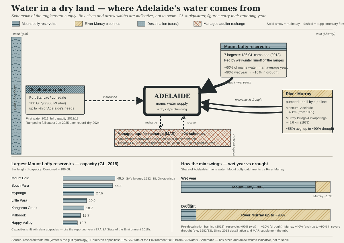
That gap between the creek Light hoped for and the creek that actually exists is the whole plot of the region’s water story. A stream this unreliable could never carry a growing city through a rainless summer on its own, which is exactly why the hills behind Adelaide filled with reservoirs, why pipelines were eventually built to lift water over the ranges from the Murray, and why the city turned to the sea itself with a desalination plant. Every one of those expensive fixes is downstream, literally, of one plain fact the Torrens announces each February: this is a Mediterranean climate, the rain that matters falls in winter, and the creek the city was founded on was never going to be enough (Goyder 1865; Cowling et al. 1996).
To read the Torrens well is to stand on the lake’s edge in late summer and see past the rowers and the reflected office towers to the dry bed the weir is holding back — and then to recognise the same rule written larger, in Goyder’s Line out on the plains and in every reservoir wall in the ranges: in this landscape, water is a winter inheritance that has to be caught, banked and defended, or it is not there when you need it.
Sources for this guide · 4
Every claim here is traceable. Each citation links to its entry in the bibliography.
- Department of Water, Land and Biodiversity Conservation (2003). Surface Water Assessment of the Upper River Torrens Catchment. DWLBC Report 2003/24. https://www.waterconnect.sa.gov.au/Content/Publications/DEW/dwlbc_report_2003_24.pdf — River Torrens length, catchment area and seasonal (ephemeral) flow character.
- Goyder's Line. SA History Hub (History Trust of South Australia); primary artefact: Goyder's 1865 hand-drawn map, State Library of South Australia. https://sahistoryhub.history.sa.gov.au/subjects/goyders-line/ — The same reliable-rainfall logic that leaves the Torrens dry each summer, read at colony scale.
- Cowling, R.M., Rundel, P.W., Lamont, B.B., Arroyo, M.K. & Arianoutsou, M. (1996). Plant diversity in mediterranean-climate regions. Trends in Ecology & Evolution 11(9):362-366. https://doi.org/10.1016/0169-5347(96)10044-6 — The Mediterranean wet-winter/dry-summer mechanism behind the river's seasonal failure.
- Amery, Rob & Buckskin, Vincent (Jack) Kanya (2014). Pinning down Kaurna names: linguistic issues arising in the development of the Kaurna Place Names Database. In I.D. Clark, L. Hercus & L. Kostanski (eds), Indigenous and Minority Placenames: Australian and International Perspectives, ch. 10, pp. 187ff. Canberra: ANU Press. https://press-files.anu.edu.au/downloads/press/p286811/pdf/ch101.pdf — Kaurna place-naming register — Karrawirra Pari / Karrawirraparri and its meaning.
Concepts this teaches — follow a thread
Goyder's Line (where the saltbush begins)The Mediterranean bargain (two seasons, not four)
More guides like this
Barker InletCleland — the range frontHallett Cove — the glacial pavementMorialta — a hills gorgeMount Lofty summitNgarkat — the great mallee reserve
Test yourself →
You are standing at the edge of Torrens Lake in the middle of the city in late summer. The water is a calm, level sheet reflecting the office towers, rowers glide past, and red gums line the banks — but a low weir crosses the water just downstream, and beyond it the streambed looks patchy and puddled rather than a continuous flow. What are you actually looking at?
Cues: A calm, level, permanent-looking sheet of water in the city centre · A low weir crossing the water just downstream of the lake · Beyond the weir, a patchy, puddled bed rather than a continuous flow · Red gums lining the banks — the trees the Kaurna name for this river records · The scene is in late summer, the dry half of the year
The Torrens is naturally a seasonal, ephemeral stream — reliable in the wet winter, shrinking to disconnected pools through the rainless summer (DWLBC 2003). Torrens Lake is not the river behaving normally; it is a weir holding water back at civic scale so the city always has a calm sheet to look at, which is why the bed just downstream of the weir shows the creek's real, patchy summer character. The red gums are the very trees recorded in the Kaurna name Karrawirra Pari — a red-gum forest river of shaded pools, not a single continuous flow — so both the vegetation and the hydrology point to the same reading.