A place
The Hills Face scarp
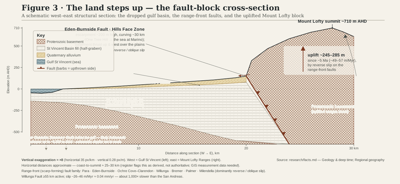
The blue wall behind the city is not scenery but a fault scarp mid-stroke — the torn edge of the Eden-Burnside Fault, kept green by a planning line and still, slowly, rising.
- On the gradient
- The step itself — the fault-line join where the dropped gulf basin meets the rising ranges block
- Rock
- Eden-Burnside Fault Zone — reverse faulting thrusting Proterozoic basement over Quaternary plains alluvium
- Soil
- Shallow, rocky range-front soils on uplifted basement, grading downslope to the plains' young alluvial fans
Locate this place on the map →
What you'll take away
- Identify the abrupt, wall-like profile of the range front as a fault scarp, not an ordinary eroded hill edge.
- Name the Eden-Burnside Fault and explain the reverse-slip mechanism thrusting old basement rock up and over the young plains.
- Explain why the Hills Face Zone keeps the scarp green for reasons of view and backdrop, not seismic safety — and why that is a coincidence worth noticing, not a design.
- Connect the scarp to the region's wider active-fault story — the ranges rising while summits erode only slowly, so relief keeps building.
Drive into Adelaide from almost any direction and, sooner or later, you meet the wall. It sits along the eastern edge of the city, blue-grey and startlingly abrupt, rising some two hundred metres in a single uninterrupted step rather than the long, worn-down roll you would expect of an old, quiet continent. It is a fault scarp — the torn lip of the Eden-Burnside Fault, and country still, slowly, on the move.
The mechanism is the startling part. Australia is supposed to be the tectonically boring continent, riding mid-raft, far from the grinding plate boundaries where mountains get made. But a raft is rigid, and stress applied thousands of kilometres away — at the Himalayan collision, the crumple zone against New Guinea, the grind past New Zealand’s Southern Alps — still travels inward through the stiff crust and squeezes south-central Australia roughly east to west. Along the range front, old basement faults take up that load the way faults always do under compression: not by rifting anything new open, but by shoving one old block up and over another. Here, ancient Proterozoic basement rock is being thrust west and up, over the young gravels and sands the plains are made of, at a rate, averaged over the last five million years, of something like fifty metres every million years (Sandiford 2003; Quigley 2010). That sounds glacial, and it is, yet the same family of range-front faults has produced repeated large surface-rupturing earthquakes over the last several hundred thousand years, and remains long enough and active enough to host a serious one again (Clark 2022). Adelaide’s most active geological feature sits at the foot of the eastern suburbs, doing its slow work in full view.
There is an irony in how the scarp has been kept clear enough to see at all. Since the 1960s a planning overlay called the Hills Face Zone has kept the steep face of the ranges largely free of housing, holding the line from north of Gawler to south of the Fleurieu with generous minimum lot sizes. The reason given was never the fault — it was the view, the leafy backdrop the ranges make for the city below. The effect all the same has been to leave Adelaide’s most active geological feature dressed as parkland: paddocks and remnant woodland standing in, by accident, for a seismic buffer nobody set out to build. Read the scarp on your next clear-morning drive and you are reading a machine mid-stroke, not a view.
Sources for this guide · 3
Every claim here is traceable. Each citation links to its entry in the bibliography.
- Sandiford, M. (2003). Neotectonics of southeastern Australia: linking the Quaternary faulting record with seismicity and in situ stress. Geological Society of Australia Special Publication 22:107–119. — Neotectonic uplift rates on the range-front faults and the timing of the modern E-W stress field.
- Clark, D., Griffin, J., La Greca, J., Quigley, M. et al. (2022). Large earthquake recurrence on the Willunga Fault, South Australia. AEES 2022 National Conference. https://aees.org.au/wp-content/uploads/2022/11/42-Clark-et-al.pdf — Willunga Fault slip rate and earthquake recurrence, for the scale of range-front fault activity.
- Quigley, M.C., Clark, D. & Sandiford, M. (2010). Tectonic geomorphology of Australia. Geological Society, London, Special Publications 346:243–265. https://doi.org/10.1144/SP346.13 — The reverse-fault, basement-over-plains mechanism raising the Mount Lofty Ranges.
Concepts this teaches — follow a thread
More guides like this
Barker InletCleland — the range frontHallett Cove — the glacial pavementKarrawirra Pari — the TorrensMorialta — a hills gorgeMount Lofty summit
Part of these pathways
Test yourself →
You are driving into Adelaide along the eastern edge of the plain. Ahead the ranges do not roll upward gradually the way a long-eroded old landscape should — instead they stand as an abrupt, blue-grey wall, climbing some two hundred metres in a single uninterrupted step. Paddocks and remnant woodland run right up the foot of that wall; no suburb climbs its face. What are you looking at, and why does it stand up like that?
Cues: An abrupt, blue-grey wall rising ~200 m in one uninterrupted step, not a long worn-down roll · Paddocks and remnant woodland running right up the foot of the range, with no housing climbing the face itself · The step follows a straight, fault-controlled line, not an irregular erosional edge
The abrupt, wall-like step is the signature of active reverse faulting, not ordinary erosion: along the Eden-Burnside Fault, ancient Proterozoic basement is being thrust west and up over the young alluvium of the plains at a rate averaged around fifty metres per million years over the last five million years (Sandiford 2003; Quigley, Clark & Sandiford 2010). The clear, paddock-and-woodland face is not a seismic buffer someone designed — it is the Hills Face Zone, a planning overlay dating from the 1960s that has kept the range front free of housing for reasons of view and backdrop, leaving the region's most active geological feature looking, by accident, like parkland.