A place
The samphire coast
The salt-soaked frontier where Gulf St Vincent meets the plains — samphire flats, the world's most southerly mangroves, and a mudflat larder that fuels shorebirds all the way to the Arctic.
- On the gradient
- The salt threshold — the lowest, saltiest ground at the foot of the gulf-to-range gradient
- Rock
- Holocene tidal mud and estuarine sediment over the St Vincent Basin
- Soil
- Waterlogged, saline-to-sulfidic intertidal mud (acid-sulfate risk when disturbed)
Locate this place on the map →
What you'll take away
- Name the two salt strategies of the flat — the samphire that stores salt and the mangrove that excludes and excretes it — and read the flat as a salinity gradient, not wasteland.
- Explain why a treeless grey flat is one of the coast's most valuable habitats: nursery, blue-carbon store, storm buffer and shorebird refuelling stop.
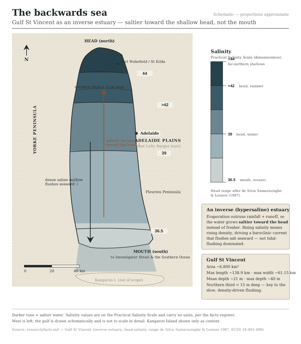
- Connect the samphire coast to the inverse estuary offshore, and to the threatened birds — the slender-billed thornbill, the Arctic-bound migrants — that depend on it.
Between the sea and the solid ground of the plains lies a strip of country that cannot make up its mind which it is. Twice a day the tide floods across it and twice a day it drains away, leaving a low, glistening world of mud and salt-crusted flat that is neither properly sea nor properly land. To a passing eye it looks like wasteland — flat, grey-green, treeless, humming with mosquitoes. It is one of the most productive and improbable environments in the whole Adelaide region, and it runs on a single difficult trick: living in salt.
The plant that gives the coast its name is samphire — not one plant but a family of low, fleshy, jointed glassworts that the botanists file under Tecticornia. Samphire do the thing most plants find fatal: they drink salt water, swelling with the brine and packing the salt away in their succulent flesh (Tecticornia 2024). In the heat of late summer, as they concentrate the salt, whole flats flush from blue-green to deep crimson, and the coast north of the city turns, for a few weeks, a startling red. Where the flats meet open water, the samphire gives way to the one tree tough enough to stand with its roots in the tide: the grey mangrove, Avicennia marina. South Australia has just this single mangrove species, and the forests it makes around St Kilda and Barker Inlet are among the most southerly on the planet, a tropical way of life growing at its cold limit. It handles the salt the other way — turning most away at the roots, sweating the rest out through its leaves, and pushing up beds of little breathing snorkels through mud too airless for ordinary roots.
None of this looks valuable, and all of it is. The waterlogged mud buries carbon and keeps it, hectare for hectare outpacing most forests; the channels are a nursery where the gulf’s prawns, whiting and blue swimmer crabs begin life; the flats soak up storm surge that would otherwise gnaw at the shore. Ugly and useful in equal measure, Australia’s temperate coastal saltmarsh is now formally listed as a Vulnerable, threatened community, having been drained, filled and written off as wasteland for two centuries (Saltmarsh 2013). And the mudflat larder feeds a spectacle you would never guess at: each spring, tens of thousands of shorebirds arrive here from the Arctic, fatten on the tiny invertebrates of the mud, and throw themselves back north to breed — so that every scrap of this grey ooze is helping to power a journey to the top of the world and back.
It is not durable. In 2020 a stretch of the St Kilda mangroves and saltmarsh abruptly died, poisoned by hypersaline brine that leaked from an adjacent salt field into the tidal flats — a blunt reminder of how finely balanced life at the salt limit is. The samphire itself is losing its seaward edge as the sea creeps up faster than the plants can colonise new ground behind (Delta 2017). And bound to this shrinking habitat is a small dun bird found almost nowhere else, the slender-billed thornbill of Gulf St Vincent, so tied to the samphire that it, too, is listed as vulnerable. Lose the samphire and you lose the thornbill, a rung of the great migration, a carbon store and a nursery. Which is rather the point of learning to see it as something other than wasteland.
Sources for this guide · 4
Every claim here is traceable. Each citation links to its entry in the bibliography.
- de Silva Samarasinghe, J.R. & Lennon, G.W. (1987). Hypersalinity, flushing and transient salt-wedges in a tidal gulf — an inverse estuary. Estuarine, Coastal and Shelf Science 24(4): 483–498. https://www.sciencedirect.com/science/article/abs/pii/0272771487901296 — The hypersaline, inverse-estuary gulf the samphire coast fringes.
- Delta Environmental Consulting (2017). Thornbills, Samphires and Saltmarsh Tipping Points. Report for the Department for Environment and Water / Eyre Peninsula NRM, South Australia. https://cdn.environment.sa.gov.au/landscape/docs/ep/thornbills-samphires-saltmarsh-tipping-points-delta-environmental-consulting-2017-rep.pdf — Samphire and saltmarsh condition and sea-level tipping points on Gulf St Vincent.
- Threatened Species Scientific Committee / DCCEEW (2013). Conservation Advice: Subtropical and Temperate Coastal Saltmarsh (ecological community, listed Vulnerable under the EPBC Act 1999). https://www.dcceew.gov.au/environment/biodiversity/threatened/conservation-advices/subtropical-temperate-coastal-saltmarsh — Temperate coastal saltmarsh listed as a Vulnerable threatened community.
- Threatened Species Scientific Committee / DCCEEW (2024). Conservation Advice for Tecticornia flabelliformis (bead/fan samphire). http://www.environment.gov.au/biodiversity/threatened/species/pubs/82664-conservation-advice-20082024.pdf — Samphire (Tecticornia) biology and conservation status.
Concepts this teaches — follow a thread
More guides like this
Barker InletCleland — the range frontHallett Cove — the glacial pavementKarrawirra Pari — the TorrensMorialta — a hills gorgeMount Lofty summit
Part of these pathways
A day on the samphire coastBirds of the flywayThe gradient (for students)The backwards seaThe whole gradient — gulf to summit
Test yourself →
You are standing on a flat, treeless plain just north of the city at low tide. Underfoot is soft grey mud that smells faintly of sulphur. Low, fleshy, jointed plants like strings of little green sausages carpet the ground, and in the late-summer heat whole sweeps of them have flushed deep crimson. Seaward, a band of low dark trees stands in the tidal mud on a bed of upright, pencil-thin roots. Which of the region's worlds are you standing in?
Cues: Soft grey mud that smells of sulphur underfoot · Low, fleshy, jointed 'sausage' plants carpeting the flat · Whole sweeps of them flushed crimson in late-summer heat · A seaward band of low dark trees standing on upright pencil-roots
Every cue says salt and tide. The jointed 'sausage' plants that flush crimson as they concentrate salt are samphire (Tecticornia); the sulphurous grey ooze is airless tidal mud; and the band of low trees on a bed of upright pencil-roots is grey mangrove breathing through pneumatophores. Mallee, stringybark forest and an inland saltbush plain are all somewhere else on the gradient — none of them grows salt-storing samphire in tidal mud. (Ch 10.)
Gulf St Vincent is described as an 'inverse' or 'backwards' estuary. As you travel from its mouth off Cape Jervis up to its northern head past the city, what happens to the salinity of the water — and why?
An ordinary estuary is freshened by a river at its head and grows saltier toward the sea. Gulf St Vincent runs backwards: it has no major river, and its broad, shallow northern third loses water to evaporation faster than rain and runoff replace it through the long dry summer. So salinity climbs from an oceanic ~36.5 at the mouth to ~39 in winter and past 42 by late summer at the head — saltier than the open sea. (The desalination brine is a real concern precisely because the head flushes slowly, but it is not the cause of the natural gradient.) (Ch 9; Lennon 1987.)
Samphire and the grey mangrove share the same tidal flat but solve the problem of living in salt water in opposite ways. Which pairing correctly describes their two strategies?
Samphire (Tecticornia) is a salt-accumulator — it takes up brine and packs the salt into its succulent, jointed flesh, which is why it flushes crimson as it concentrates the load in late summer (Tecticornia 2024). The grey mangrove, Avicennia marina, takes the opposite path, excluding most salt at the root and pushing the remainder out through its leaves — which is why only the samphire reddens, while the mangrove simply stays green. Two neighbouring plants on the one flat, two different answers to the one hard problem of living in salt.